
SUMMER 2013 CONTENTS
Home
Hiding in plain sight
The environmental factor
Priming the pumps
Debugging Dhakas water
Close encounters
How we're crossing paths with disease-bearing pests
Street smarts
Using citizen-scientists to fight for healthier neighborhoods
Beyond hurricane heroics
What Sandy should teach us all about preparedness

DOWNLOAD PRINTABLE
ISSUE (PDF)
Special Report
Street smarts
Using citizen-scientists to fight for healthier neighborhoods
By Kris Newby
Photo by Leslie Williamson
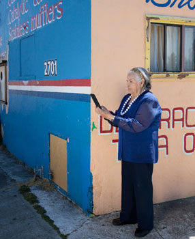
Feliciana Jimenez documenting hazards in her neighborhood.
Feliciana Jimenez, an 80-year-old with nine children, squints with a critical eye at the camera window of a tablet computer. Through this lens, she sees her street in a whole new light. She takes pictures of crumbling sidewalks and a construction worker’s hose, coiled like a snake at her feet. She hits the record button on the tablet to describe how these hazards could cause seniors to trip and fall. She captures images of clogged sewer drains covered in stagnant water that could breed mosquitoes. As each hazard is recorded, the tablet saves its precise location on a map, using the device’s built-in geographic positioning system.
Jimenez lives in North Fair Oaks, Calif., nicknamed Little Mexico by locals. It is a working-class community within Silicon Valley that has been passed over by the tech-driven gentrification that has lined streets of neighboring towns with shade trees, sidewalk cafes and farmers’ markets.
To fight for a safer, healthier neighborhood, Jimenez volunteered to test two new devices — a customized tablet computer and a wearable camera — both of which can be used to notify city planners about things that need to be fixed and improved, from hardscapes to landscapes.
The benefits of these changes in the “built environment” — the man-made structures that define a place — go well beyond aesthetics: People who live in places that promote walking, socializing and eating fresh foods are physically and mentally healthier than those who do not.
Abby King, PhD, a Stanford professor of health research and policy and of medicine, initially developed the customized tablet for documenting neighborhood hazards as a way of helping San Mateo County with its Grand Boulevard Initiative, which aims to improve the safety and aesthetics of El Camino Real, the busy retail thoroughfare that runs through the county. As part of the new project, King and her team at the Stanford Prevention Research Center are creating a social blueprint for teaching residents and grassroots organizations how to persuasively communicate these community needs to city planners.
But in this era of government gridlock and dwindling funds, reworking the car-centric landscapes of the last century isn’t going to be easy.
Jimenez’s street is lined with boxcar rows of post-war houses adorned with cast-iron grates on windows, brick fences and plaster lawn ornaments. Homes are mixed in with light industry — an auto repair shop, a welder and a cabinetmaker. Around the corner are small retail stores selling Mexican groceries, piñatas and quinceañera gowns in Easter-egg colors.
While most of the houses in the neighborhood are tidy and well-maintained, at midday the neighborhood has a glaring, hard edge to it. Looking at an aerial view of North Fair Oaks via Google’s satellite map, it’s obvious why — there are very few trees. North Fair Oaks’ concrete-colored grid of streets forms a visible line against the emerald-green border of neighboring Atherton, the second most expensive real estate market in America, known for its meandering lanes shaded by live oak canopies.
As Jimenez walks down her street, two Stanford researchers observe how she interacts with the tablet computer, looking for ways to improve it. Called the Stanford Healthy Neighborhood Discovery Tool, the simple-to-use tablet is loaded with software developed by King’s team to track users’ walking routes and geographically tag hazard locations, linking them with audio narratives and photographs. Afterward, it leads the user through a questionnaire about the walk.
As Jimenez stops to snap pictures of graffiti and an overflowing trash bin, the two researchers — Sandra Jane Winter, PhD, a Stanford postdoctoral scholar, and Priscilla Padilla Romero, MPH, MPP, a community partner from San Mateo Medical Center — take a few moments to show her how to verbally record her impressions of each neighborhood feature. They notice that the slick plastic tablet is hard for her to grasp, and that the tablet’s screen is difficult to read in the bright sunlight.
The custom software tracks users’ walking routes and geographically tags hazard locations, linking them with audio narratives and photographs.
After the walk, hazard images and location coordinates can be uploaded to an online map, which can be shared with researchers, city planners, policymakers or others involved in the project. The walking routes of all participants are overlaid on the map, making it easy to identify the more frequently walked routes where repairs need to be made first.
Jimenez also wears a Microsoft SenseCam camera around her neck; it automatically snaps a picture of everything in her field of vision every 12 seconds. Later these images will be analyzed using software developed by King’s collaborators at the British Heart Foundation Health Promotion Research Group in Oxford, England. The image-analysis software organizes these photos into discrete, time-coded activities, adding another layer of understanding to how people interact with their environment. For the purposes of King’s studies, the camera’s built-in GPS function provides information on distances and walkability to food sources, jobs and local transportation. It also allows researchers to identify hazards that participants might have overlooked.
King’s dream is that her tablet-based tool will provide a low-cost way for community advocates in places like North Fair Oaks to work with city officials to improve their neighborhoods. But before she launches it into the world, she and her Healthy Aging Research & Technology Solutions team need to collect more evidence to not only improve the tool, but to teach community groups how to use it.
King first became interested in ways to improve the quality of life for seniors while studying clinical psychology at Virginia Tech. As she began her postdoctoral work at Stanford University, she watched a beloved grandfather grow frail and slowly die. It motivated her to abandon her plan to work one-on-one with patients, and instead to look for ways to alleviate the suffering of aging populations on a larger scale.
“From when I first met her, Abby was passionate about getting older adults out there exercising as a way of preventing chronic disease,” says Marcia Stefanick, PhD, professor of medicine and of obstetrics and gynecology, who has worked with King at Stanford since the early 1980s. “And since then she’s been researching the best ways to leverage principles of human behavior to get people off the couch and out doing healthy things.”
Recently King has been exploring the use of mobile technologies to encourage people to exercise more. Last year she developed a mobile phone app that appeals to the social nature of users, allowing participants to motivate each other to increase their walking throughout the day and to compare their team’s performance to other teams’. Another app appeals to nurturing instincts by allowing users to adopt a virtual pet bird that exhibits either good health or bad, based on the daily healthy habits of its owner.
Behind King’s latest idea, using the tablet to document neighborhood hazards, is growing evidence that improving a town’s built environment results in happier, healthier residents. A key tactic is to get people out of their cars.
How to do that? Urban planners suggest clustering retail stores near mass transportation hubs, adding bike lanes and changing zoning rules to encourage more sidewalk cafes and fewer drive-through restaurants. Adding public squares, benches, farmers’ markets and dog and people parks forges social connections, which in turn reduces crime and isolation-driven depression.
Enhancing the aesthetics of the pedestrian experience can also motivate people to walk more. Some proven strategies include widening sidewalks, adding pedestrian-oriented street lighting and creating green barriers to buffer the impact of traffic on shoppers. In addition, reducing the number of lanes can slow traffic and make crossing the street safer.
The health benefits of neighborhood walkability have been documented in a number of recent studies. For example, a 2004 study published in the American Journal of Preventive Medicine by Lawrence Franks, PhD, found that for each hour spent in a car each day, a commuter has a 6 percent greater chance of being obese than non-commuters. He also found that people who lived within walking distance of shops and businesses were 7 percent less likely to be obese.
Notably, another study involving regular exercisers (defined as those who exercised at least 2.5 hours per week), found that, even among this reasonably active group, those with long car commutes gained an average of 4.8 pounds over four years, 2 pounds more than their non-driving peers. This study by Takemi Sugiyama, PhD, was published in the February 2013 issue of the American Journal of Preventive Medicine.
About a year ago, King and her team tested the precursor to the tablet within a population of 400 seniors in East Palo Alto, a town 5 miles from North Fair Oaks. This study looked at ways to better inform city planners about the physical barriers to fresh-food sources. Both North Fair Oaks and East Palo Alto have median household incomes of about $50,000, below the California average. These cash-strapped cities with lower tax bases haven’t had the luxury of investing in as many infrastructure improvements as their wealthier Silicon Valley towns, and the health of their populations has suffered.
In February, King’s team celebrated its first success, after being contacted by Brent Butler, planning manager for East Palo Alto.
“Some of the street issues that this Stanford study brought to our attention have been added to our comprehensive sidewalk inventory and repair program,” says Butler.
These suggestions were influential in the city’s addition of countdown timers to crosswalks on its main thoroughfare, University Avenue, to ensure that seniors and children allow enough time to cross. The study also helped the city document sidewalk obstacles that impede movement of people using wheelchairs, walkers and strollers.
Some of these future improvements may be funded by an unexpected patron, the new kid in the ’hood, Mark Zuckerberg, founder and CEO of Facebook. In July 2011, Facebook employees moved into the former headquarters of Sun Microsystems, a fortress-like quadrangle of buildings located between East Palo Alto, a six-lane freeway and the salt marshes of the San Francisco Bay. Because of its isolation, previous employees nicknamed the campus “Sun Quentin,” after San Quentin State Prison.
The first thing that Facebook managers did was give the campus a built-environment makeover. They added a winding main street down the center of campus, and lined it with cafes, shade trees, coffee shops and racks of loaner bikes. The company has also pledged more than $800,000 annually to East Palo Alto and neighboring towns over the next 15 years to help improve traffic flow and create better pedestrian and bike paths.
This fortuitous collaboration with Facebook shows how valuable it is to have “shovel-ready” priorities documented when funding opportunities arise and how useful the discovery tool tablet can be for identifying those priorities. It’s also an example of how some Silicon Valley companies, including Google and Apple, are building campuses that directly promote physical activity among their employees.
King, Winter and former Stanford Prevention Research Center postdoctoral scholar Matt Buman, PhD, now at Arizona State University, would like funding to refine the tool and teach community groups how to communicate their needs to city planners.
“In general, it’s difficult to get funding for any research project in the current fiscal climate,” says Buman, “but it’s even harder for a project like this, because it doesn’t fit neatly into National Institutes of Health funding categories. It’s part prevention and public health, part behavioral science and part urban revitalization.”
In Arizona, Buman has had volunteer shoppers use the tool at a farmers’ market to provide feedback to the organizers on how to improve it.
To date, King and Winter have collected data from 15 of the 40 volunteers planned for the North Fair Oaks study, which is funded by the medical school’s Office of Community Health by a seed grant from Spectrum, which oversees Stanford’s NIH Clinical and Translational Science Award.
Next, they will organize a community advocacy meeting to help the study participants prioritize neighborhood issues by importance to the community and feasibility of being addressed. Together, these residents will develop an action plan and present the ideas to local health policymakers.
“This phase of the study is important because it ensures that the community members, not outside researchers, are advocating for change within their own neighborhoods,” says Winter, who grew up near many poverty-stricken towns in South Africa. She is motivated to help these communities in a way that respects their unique cultures and needs. She also feels that changes that come directly from residents are more likely to be successfully implemented.
She adds, “The other benefit to this study is that it raises overall awareness about features of the environment — both the good and the bad — that affect our ability to live healthy lives.”
As the team finishes this study, it’s developing a software module for the discovery tool that will allow researchers to study how people access food in their neighborhoods and what drives their food choices. This new software will be tested in north San Mateo County and several neighborhoods in Mexico.
“Research shows that it is never too late to make healthy behavior changes and even small changes in the built environment can have a potentially big impact on critical health behaviors — including regular physical activity, healthful diets and avoiding tobacco use. These health behaviors are among the key drivers of the chronic diseases that are the nation’s leading causes of death and disability,” says King. “Chronic diseases, such as heart disease, cancer and diabetes, result in tremendous economic, societal and personal costs, both in the United States and globally, yet they are potentially avoidable. By simply making a town more walkable, we can help to enhance the health and quality of life for much of our population by a significant degree.”
In this era when cities need to rethink their car-centric urban landscapes and to explore creative ways to control rising health care costs, using citizen-scientists to lobby for more beautiful, walkable neighborhoods might be just what the doctor ordered.